This is the city of Cuzco, Peru at altitude 3400M (11,200 Ft) it is one of the highest cities in the world. Cuzco is a UNESCO world heritage site and was the historic capital of the Inca empire. There are Inca sites dotted in and around the city and many of the buildings in the city are built on or incorporate Inca structures. This is a view of the city taken from the surrounding hills.
 Today the city is expanding and housing is beginning to creep up the mountainsides.
 This is a view of the main square. Cuzco has a number of beautiful buildings from the Spanish colonial era including these two cathedrals that face each other on the square.
 L at the fountain in the main square at Cuzco.
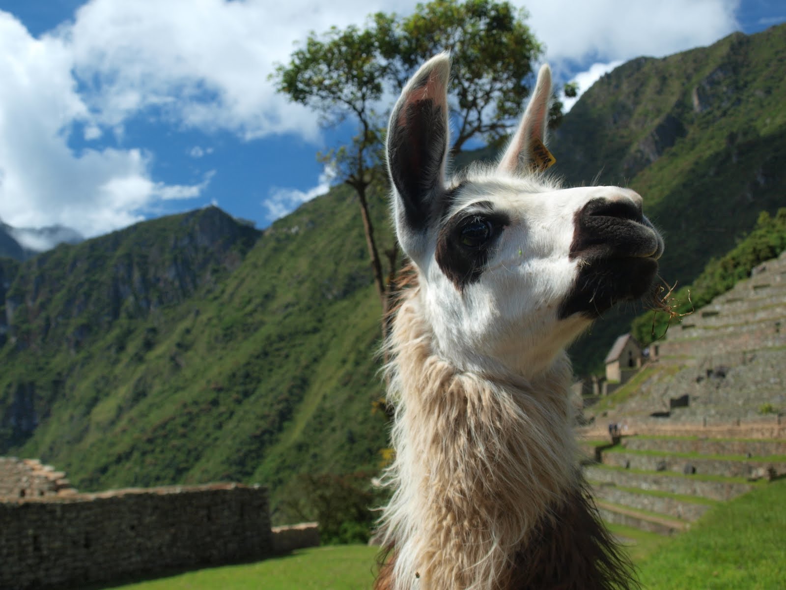
"Hey, you talkin to me?"
 The drive from Cuzco to Puno crosses the high plains and plateaus between some of Peru's highest peaks. This area is known as the altiplano.
 Getting from Cuzco to Puno and Lake Titicacca involves a 400 KM road journey accross the altiplano. It is pretty windy up here.
 This is big open country. Above shot shows the train which makes the same journey - the train actually takes longer then driving
 D hanging out in front of some 5000M peaks complete with glacier
 I really like this shot - notice the small cabin in the bottom of the frame - this gives you an indication of how vast and open this wild place really is
 Close up shot of the glacier higher up the mountain
 Some more wild Andean mountain scenery on the way to Puno
 This shot of some terraced fields was taken on the island of Taquile in Lake Titicacca about 35KM east of Puno. At 3812M ( 12,500 Ft) Lake Titicacca is the highest navigable lake in the world. One end of the lake is in Peru, the other in Bolivia. By volume it is also the largest lake in South America.
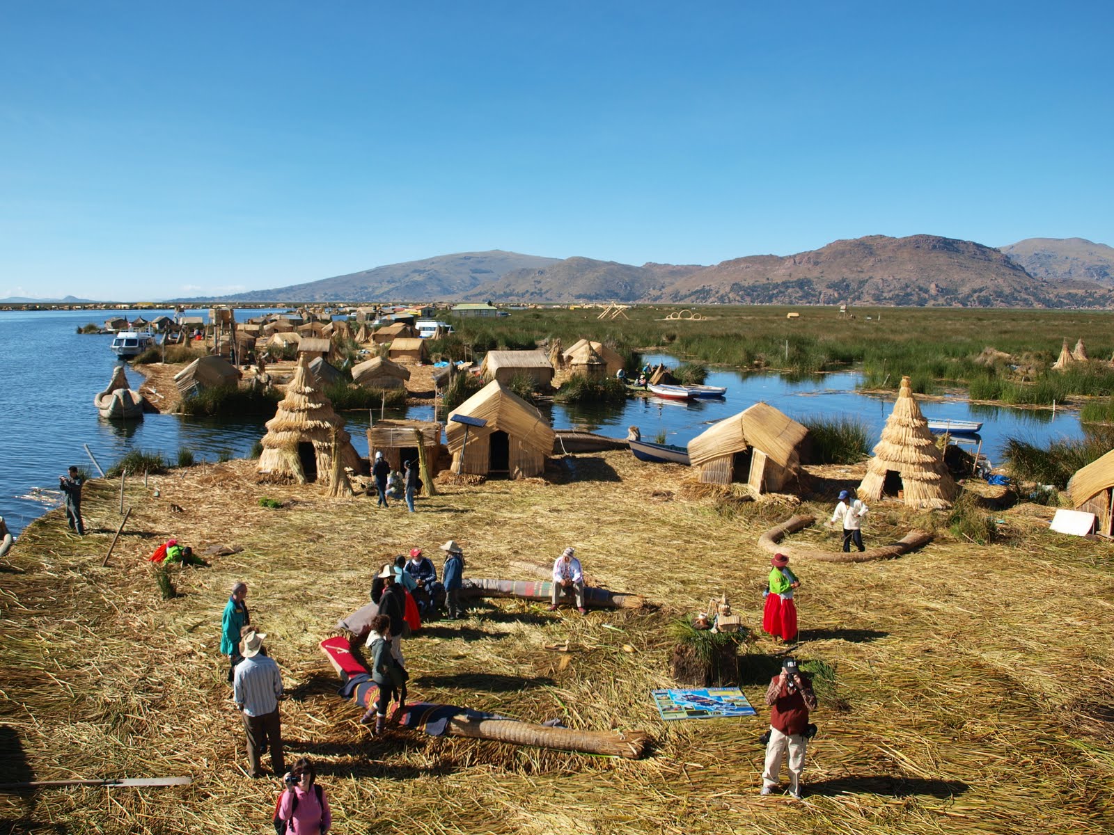
  A really interesting place to visit are the Uros, a group of 42 artificial islands made of floating reeds. The Uros people who live on these islands in a community of approx 2000 speak a tribal language called Aymara. The islands are anchored with ropes and sticks driven into the bottom of the lake. Each island lasts about 30 years and are constantly being replenished with fresh reeds.
 In the shot above a number of villagers turn out to welcome us to the island.

 This shot is taken from a lookout tower on one of the islands.

 Above, one of the locals in traditional costume taking a walk.
 Below, a view of Puno from the shores of Lake Titiccaca
 Some scenes from the street markets in Puno


 Below, here we are having lunch in a Lima restaurant on our last afternoon. Jesus was our guide and had the unenviable job of keeping D & L out of trouble throughout our travels in Peru. This of course was an almost impossible task fraught with difficulties. But here we are, all intact (well almost) on the last afternoon. Jesus's friend Cynthia also joined us for lunch This last lunch was a nice send off.

 This shot is taken from a lookout tower on one of the islands.
 Above, one of the locals in traditional costume taking a walk.
Military parade in the main square of Puno
 Below, a view of Puno from the shores of Lake Titiccaca
 Some scenes from the street markets in Puno


 Below, here we are having lunch in a Lima restaurant on our last afternoon. Jesus was our guide and had the unenviable job of keeping D & L out of trouble throughout our travels in Peru. This of course was an almost impossible task fraught with difficulties. But here we are, all intact (well almost) on the last afternoon. Jesus's friend Cynthia also joined us for lunch This last lunch was a nice send off.
We left Lima about two hours later for the airport and sadly, the end of the South American part of our Big Trip and our flight home.
 Thanks for watching.
 Coming soon, summer in France. Watch this space!